


The China Meteorological Administration raised its major meteorological disaster emergency response on Monday morning, escalating it from level four, the lowest, to level three, and expanding the alert to cover both torrential rain and severe convective weather.
")
Meanwhile, the National Meteorological Center has renewed a blue alert for severe convective weather, the lowest level of its three-tier warning system, adding that powerful thunderstorms, hail and torrential downpours will sweep across large parts of the country.
The center said that from Monday afternoon through Tuesday afternoon, thunderstorms accompanied by gale-force winds above level 8, equivalent to gusts of at least 62 kilometers per hour, or hail are likely to hit some areas of central and eastern parts of North China and the southern part of South China.
In some areas of Hebei province, Beijing and Tianjin, winds will be even stronger, with gusts exceeding level 10, meaning speeds of more than 88 km/h.
Meanwhile, intense bursts of short-duration heavy rain are forecast for central and southern parts of Northeast China, central and eastern parts of North China, central and southern parts of South China and southern part of Southwest China. These storms could deliver hourly rainfall of more than 20 millimeters.
The downpours are expected to be heavier in the southern part of Hebei, the southeastern part of the Guangxi Zhuang autonomous region and the southern part of Guangdong province, where hourly rates may surpass 50 mm and could peak above 90 mm.
The center said that from Monday through Wednesday, heavy to violent rainfall is expected to hit most parts of Guangdong and Guangxi, central and southern parts of Fujian province, the southern part of Jiangxi province, western and eastern parts of Yunnan province, the southern part of Sichuan province and the southwestern part of Guizhou province, with some areas likely to be hit by severe rainstorms.
Coastal areas of southern China will experience localized heavy downpours of extreme intensity.
The eastern part of the Inner Mongolia autonomous region, Northeast China, North China, and the eastern part of the Yellow-Huaihe River Valley are expected to experience scattered showers or thundershowers, with localized heavy rain or storms, along with short-duration heavy rainfall, thunderstorms, strong winds, hail, and other severe convective weather.
Sun Qianqian, a meteorological analyst at Weather China, a website affiliated with the CMA, said the main reason for so much rainfall recently in Northeast and North China is the frequent eastward movement of upper-level troughs and cold vortices.
"These systems continuously guide cold air southward to collide with warm and moist airflows, bringing frequent rainfall and severe convective weather," she said.
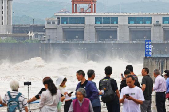
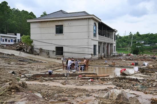
The alerts followed days of exceptional rain that have already saturated parts of Guangdong and Guangxi where over 600 mm of rainfall has been recorded.
Heavy to torrential rain, with local extreme downpours, has hit northern Guangdong, the northern Pearl River Delta, and eastern coastal areas since Friday.
As of 8 pm on Sunday, 13,283 people had been evacuated, according to the provincial emergency management department.
Affected by the rain, some trains operating between Yangcun township and Huizhou Station on the Beijing-Kowloon Railway service were adjusted on Monday, with measures including passenger diversion, suspension, and breaking a journey, railway authorities said.
Guangdong-based media Nanfang Plus reported that in Huilai county, Jieyang city, local residents reported relentless heavy rain since Saturday night, with floodwaters rising chest-deep for some ground-floor residents.
China News Service reported that the Guangxi's hydrology center said on Monday that four rivers had exceeded warning levels due to heavy rainfall, with the highest surpassing the alert mark by 1.76 meters.


 京公网安备 11010202009201号