


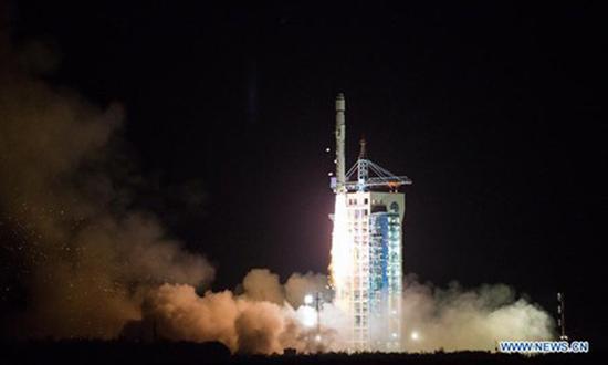
The Long March-2D rocket carrying a carbon dioxide monitoring satellite blasts off from the launch pad at the Jiuquan Satellite Launch Center in Jiuquan, northwest China's Gansu Province, Nov. 22, 2016. This was the 243rd mission of the Long March series rockets. Besides TanSat, the rocket also carried a high-resolution micro-nano satellite and two spectrum micro-nano satellites for agricultural and forestry monitoring. (Xinhua/Ren Hui)
China's first global carbon dioxide monitoring satellite, TanSat, has for the first time detected human-caused carbon dioxide emission signatures, which is one of the most important requirements needed for monitoring global greenhouse gases, according to an international research team.
The team, with researchers from the Chinese Academy of Sciences (CAS) and the Finnish Meteorological Institute, published their research in the journal Advances in Atmospheric Sciences on Tuesday.
The team analyzed measurements from the TanSat mission and the Copernicus Sentinel-5 Precursor mission, European satellite mission, to identify carbon dioxide from human activities.
Scientists conducted their study by looking at two sets of measurements collected over two cities. The team used TanSat carbon dioxide data captured in May 2018 near Tangshan, North China's Hebei Province, and in March 2018 near Tokyo, Japan. They compared the TanSat data to nitrogen dioxide measurements captured by the TROPOspheric Monitoring Instrument onboard the Copernicus Sentinel-5 Precursor satellite on the same dates over the same cities, according to CAS.
Their two case studies showed TanSat carbon dioxide measurements have the capability of capturing the anthropogenic variations in the plume and have spatial patterns like that of the TROPOspheric Monitoring Instrument's nitrogen dioxide observations.
Concentrations of carbon dioxide continue to rise because of human activities such as fossil fuel combustion and land-use change. The emissions related to the combustion of fossil fuels are particularly localized, with urban areas being the dominant contributor responsible for more than 70 percent of global emissions, Yang Dongxu, a research fellow from the Institute of Atmospheric Physics of CAS, told the Global Times on Tuesday.
The International Energy Agency (IEA) said last week that it predicted global carbon dioxide emissions would stand at 33.8 billion tons in 2022, 300 million tons more than in 2021, the AFP reported.
Yet it has been especially challenging for scientists to obtain the high precision measurements they needed to study anthropogenic emissions from cities, he said.
This is the first attempt to use TanSat measurements to detect anthropogenic, or human-caused, carbon dioxide emission signatures, Yang said.
TanSat, launched in 2016, is China's first global carbon dioxide monitoring satellite. Tan is Chinese pronunciation of carbon.
The carbon monitoring satellite helps scientists better understand the current situation of carbon emissions and carbon sinks, which could provide data support as well as policy optimization for China's carbon goals, Yang said.
China aims to have CO2 emissions peak before 2030 and achieve carbon neutrality before 2060.
Looking ahead, the team has plans to expand this research. "The TanSat is our first attempt on global carbon monitoring. The next generation of China's Global Carbon Dioxide Monitoring Satellite mission, TanSat-2, is now in the design phase," said Liu Yi, also from the Institute of Atmospheric Physics of CAS.
According to Liu, TanSat-2's target measurements will focus on recording the gradient of carbon dioxide from city central to rural areas using an imaging process and a 500-meter footprint size to improve the emission estimation accuracy. TanSat-2 will be a constellation of satellites distributed into at least two orbits in the morning and afternoon to cover a city or a point source twice a day.


 京公网安备 11010202009201号