Countries agree to continue their joint development of high-tech satellites
China and Brazil have pledged to deepen their cooperation in satellite development and applications, according to senior officials from both sides.
"We hope we can improve our collaboration so that we can send more satellites together and use these space assets to help nations in South America and Africa," Clelio Campolina Diniz, Brazilian minister of science, technology and innovation, told China Daily on Tuesday.
"We are discussing the technological feasibility of a new satellite that will be developed by the two nations," he added.
Diniz was attending a bilateral meeting on strengthening space collaboration in Beijing. The first images taken by a satellite jointly developed by China and Brazil were published at the meeting.
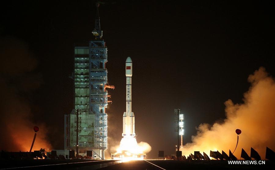
The Ziyuan-1-04, or CBERS-4 as it's known in Brazil, was sent into Sun-synchronous orbit by a Long March-4B rocket from the Taiyuan Satellite Launch Center in Shanxi province on Sunday morning. The launch marked the 200th flight of the Long March rocket family.
The device is a remote sensing satellite intended for operation as part of the China-Brazil Earth Resources Satellite Program between the China Center for Resources Satellite Data and Application and Brazil's National Institute for Space Research. The program is a technological effort that develops and operates Earth observation satellites.
The Ziyuan-1-04 carries four cutting-edge cameras, such as the infrared multispectral scanner and wide-field imager.
It is the fifth of the CBERS satellite series. The first satellite of the series, Ziyuan-1, or CBERS-1, was launched in October 1999.
The second and third satellites were launched in October 2003 and September 2007.
The fourth, Ziyuan-1-03, or CBERS-3, blasted off on a Long March-4B in December 2013 but failed to enter its preset orbit due to rocket malfunctions.
"Images generated by CBERS satellites are used in several important areas such as deforestation control and environmental monitoring in the Amazon region, water resources monitoring, urban growth observation and scientific education," the Brazilian minister said.
Brazil has received more than 120,000 images taken by CBERS satellites and almost all environmental and resources agencies and institutes in the country are users of these images.
China and Brazil also distribute some of the images to other nations free to help them monitor environment and prevent disaster.
China will strengthen its cooperation with Brazil to better use the satellite images in disaster prevention and relief as well as land resources development, said Tian Yulong, secretary-general of the China National Space Administration.
He said the next satellite in the CBERS program is expected to be launched around 2017.