


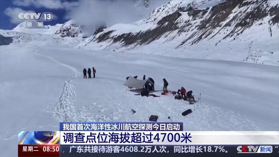
(ECNS) -- China plans to launch its first aerial survey on ocean glaciers in Qamdo, Xizang Autonomous Region, according to China Geological Survey of Ministry of Natural Resources.
The survey seeks to better understand the formation patterns and changing trends of ocean glaciers, providing fundamental data for natural resource management.
Renlongba is a typical ocean glacier in Xizang and a rare mountain glacier of mid-to-low latitude. It remains relatively well-preserved in its original state.
Given the natural conditions at high altitude, low temperature, and across vast glacier regions, the survey team has developed an "integrated space-air-ground monitoring system." This system comprehensively utilizes satellite remote sensing, helicopter-based aerial surveys, and on-site ground investigations to obtain key parameters including glacier distribution and thickness, enabling a systematic understanding of the current state and changing characteristics of China's glaciers.
The main survey areas are located at multiple sites above an altitude of 4,700 meters. This survey marks a new stage in China's resource monitoring capabilities, filling the technical gap in systematic aerial studies of ocean glaciers.
(By Li Yan)


 京公网安备 11010202009201号