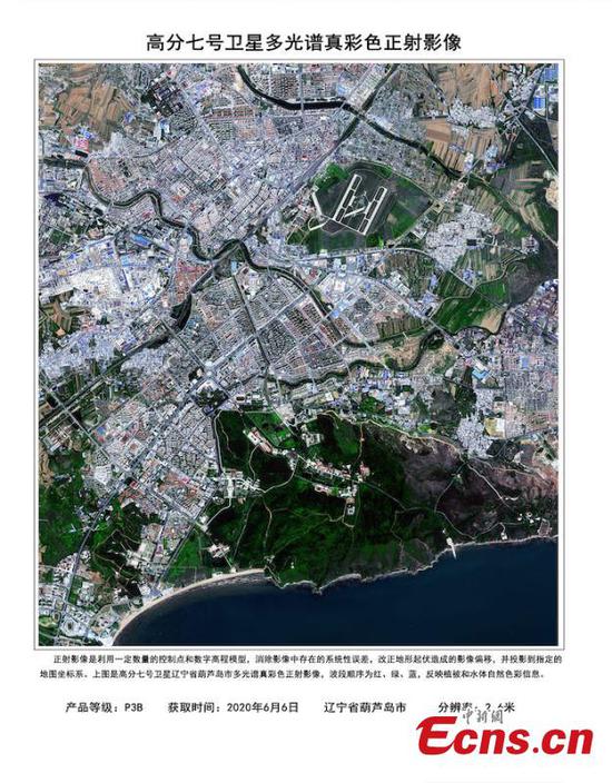
China's Earth observation satellite Gaofen-7 has been officially put into use, according to the China National Space Administration (CNSA) on Thursday.
Launched on November 3, 2019, Gaofen-7 is an important part of China's high-definition Earth observation project aiming to improve the country's orbital imaging capabilities.
Unlike other satellites in the Gaofen family, the new member combines multi-spectral cameras with highly precise laser altimetry. The camera system can capture 3D images instead of flat 2D ones, meaning the "photo" it shot can represent the target's shape in reality, not just a 2D projection.
The image resolution is down to the decimeter level, the best among the whole Gaofen series. If the image is made into a map, a centimeter on the map can represent 100 meters in reality.
It's the country's first civil-use 3D surveying and mapping satellite that reaches the sub-meter definition. Objects less than a meter across can be detected, and the depth resolution can reach about 1.5 meters.
Gaofen-7 will help solve problems in monitoring geographical conditions, housing and urban-rural construction and national statistics, according to Xinhua News Agency quoting Cao Haiyi, Gaofen-7 chief designer, at the China Academy of Space Technology.
"In the past, surveying and mapping work was labor-intensive and lasted for months or even years. With the new satellite, these tasks can be completed in minutes. Before the launch of Gaofen-7, we could only precisely locate super-highways, but now Gaofen-7 can help us accurately locate rural roads," Cao Haiyi said.