


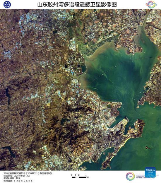
Image captured by the satellite SDGSAT-1 shows a view of Jiaozhou Bay in East China's Shandong Province. China's recently launched Earth science satellite has sent back its first remote sensing images, according to its developer, the Chinese Academy of Sciences (CAS). Using thermal infrared, low light level and multispectral imagers, the satellite captured images of multiple cities and regions, including Beijing, Shanghai, the Yangtze River Delta, Lake Namtso in Tibet, Aksu Prefecture in Xinjiang, and Paris in France. The satellite SDGSAT-1 is the world's first space science satellite dedicated to serving the U.N. 2030 Agenda for Sustainable Development. The satellite was launched into space on Nov. 5. (Chinese Academy of Sciences/Handout via Xinhua)
China's recently launched Earth science satellite has sent back its first remote sensing images, according to its developer, the Chinese Academy of Sciences (CAS).
Using thermal infrared, low light level and multispectral imagers, the satellite captured images of multiple cities and regions, including Beijing, Shanghai, the Yangtze River Delta, Lake Namtso in Tibet, Aksu Prefecture in Xinjiang, and Paris in France.
The satellite SDGSAT-1 is the world's first space science satellite dedicated to serving the U.N. 2030 Agenda for Sustainable Development.
It is designed to provide space observation data for the monitoring, evaluation and study of interactions between humans, nature and sustainable development, according to CAS.
The low light level imager can reflect the level of social and economic development in an area and the pattern of human settlements by detecting the intensity and distribution of night lights.
The multispectral imager can monitor the water color index and transparency of various turbid water bodies, and the multispectral data can be used to analyze changes in glaciers, melting snow and vegetation coverage.
The thermal infrared imager can survey changes in land surface and water temperatures as well urban heat energy distribution, providing basic data for crop cultivation, pest control and disease control.
The satellite was launched into space on Nov. 5.


 京公网安备 11010202009201号