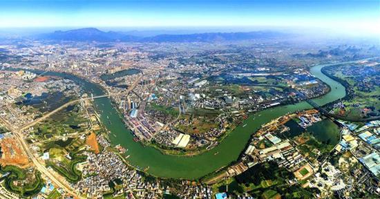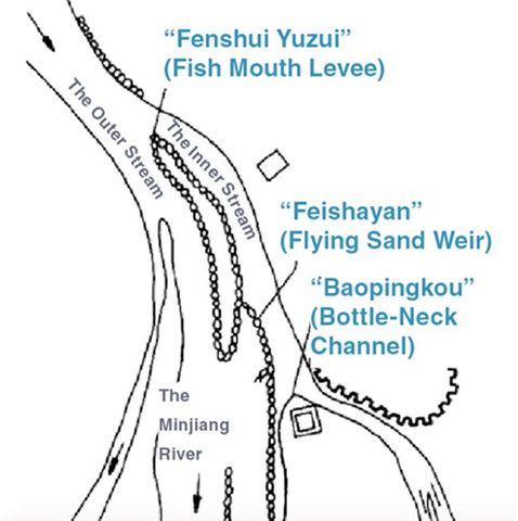
Schematic diagram of Dujiangyan
Dujiangyan, or Dujiang Weir, refers to an ancient irrigation and flood-control system in Dujiangyan City in Sichuan Province, which is one of the must-sees for tourists.
Standing at the weir and watching the surging river spitting and running through is said to be a great experience for appreciating not only the beauty of nature but also the great talents of the ancient Chinese. The system constructed around 256 BC is still working today, irrigating over 6,600 square kilometers of land and controlling floods. The Dujiang Weir, the Zhengguo Canal in Shaanxi Province and the Lingqu Canal in the Guangxi Zhuang Autonomous Region are collectively known as the “three great hydraulic engineering projects by the Qin Kingdom.”
Although famed as “the land of abundance,” Sichuan Province was not always in that way. With a sharp altitude drop from Dujiangyan to Chengdu, the Chengdu Plain was prone to flooding, as the Minjiang River, a major tributary of the Yangtze, rushes down from the Min Mountains and slows abruptly after reaching the plain, filling the watercourse with silt. The plain was often underwater in the rainy season and a thousand-mile barren patch in drought.
A waterway had been made at Minjiang River out of the mountain around 500 BC by the ancient ruler there, to distribute some of the water to the Tuojiang River to reduce the flood risk.
And in 256 BC, Sichuan governor Li Bing and his son, both engineers, led the construction of Dujiangyan, with support from King Zhao of the Qin Kingdom in the Warring States Period (476-221 BC), who thought highly of the strategic position of Sichuan in uniting China.
Rather than a simple dam, Li and his son planned to harness the river by channeling and dividing the water. Three projects were made to work in harmony, as a safeguard against flooding and to keep the fields well supplied with water. They were the “Fenshui Yuzui” (Fish Mouth Levee), the “Feishayan” (Flying Sand Weir) and the “Baopingkou” (Bottle-Neck Channel), with 100,000 taels (5,000 kilograms) of silver from the king and a team of tens of thousands of workers.
With careful study of the landform and water conditions, Li proposed building an artificial levee to redirect a portion of the river flow and cut a channel through the Yulei Mountain to discharge the excess water of the Minjiang River into the dry Chengdu Plain beyond.
The Fish Mouth Levee with its conical head resembling the mouth of a fish is the key part of Li’s plan. It is an artificial levee that divides the water into the Inner Stream toward the plain in the east and the Outer Stream in the west joining the Yangtze River eventually. The Inner Stream is deep and narrow, while the Outer Steam is relatively shallow but wide. This special structure ensures that the Inner Stream carries approximately 60 percent of the river flow into the irrigation system in the dry season. But in flood season, this amount decreases to 40 percent of protect people and farmland from flooding. In addition, the wide and shallow Outer Stream drains away the rest, flushing out much of the silt and sediment.