RIGHT BG


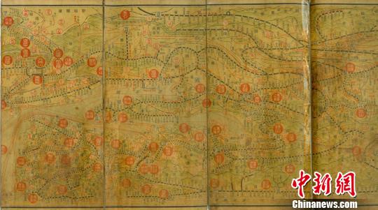

Chengde (ECNS) -- A map of old China printed for the Japanese military to assist its invasion in the 1930s and 1940s has been discovered in Hebei province, Chinanews.com reported Sunday.
The map, 20 cm in height and 72 cm in length, was found in Hebei's Longhua county. It includes sketched maps of China, Japan and Korea on its front side.
The map shows the territory and traffic lines of China in the 1930s, with areas rich in minerals and agricultural resources clearly marked.
The opposite side of the map is printed with photos of China's historic sites including the Three Gorges of the Yangtze River, the Mausoleum of Dr. Sun Yat-sen, and the Great Wall.
The map appears to have been published by a Japan-based printing company owned by Oyama Yoshisai (transliteration) in the late 1930s or early 40s.
With China's resource distribution and historic sites marked, the map shows the invaders' "aggressive ambition to carry out economic plunder and cultural looting in China," according to researchers at the Longhua County Museum.
The map was donated by Zhou Guicun, a retired employee of the local postal service.
Zhou, 86, said he got the map as a gift from his brother, a collector named Yin Qingde who brought it from Heilongjiang province.
Researchers at the museum pointed out that the map has high historical value, as it is the only such invasion map printed with photos.
Copyright ©1999-2018
Chinanews.com. All rights reserved.
Reproduction in whole or in part without permission is prohibited.