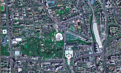


The State Administration of Science, Technology and Industry for National Defense releases the first batch of photos taken by Gaofen-2, its most advanced Earth observation satellite on Monday.
China on Monday released the first batch of photos taken by Gaofen-2, its most advanced Earth observation satellite.
Gaofen-2 can see object just a meter in length from space, in full color.
The stripes of a pedestrian crossing in the Xizhimen area of downtown Beijing are clearly visible in one of the 15 photos published by the State Administration of Science, Technology and Industry for National Defense. Part of Shanghai and an area of coal mines in Shanxi Province were also shown.
The satellite, launched on August 19, has uses in areas including land use, mineral resources and disaster relief. It is the second of seven satellites China's high-definition observation project Gaofen which will be launched before 2020. Gaofen-1 was launched in April 2013.
Three more satellites will be launched in the next two years, said Xu Dazhe, head of the administration, at a press conference on Monday.
Xu said that data acquired by the satellites will be provided to other countries.
Copyright ©1999-2018
Chinanews.com. All rights reserved.
Reproduction in whole or in part without permission is prohibited.